Walking in North East Corfu |
 |
Walking in North East Corfu |
|
Purchasing Walking in North East Corfu
Walking in North East Corfu is on sale at a price of 9.50 euros. To order, click the Buy Now button above which will take you to the payment page on the secure Paypal website where you can pay with an existing Paypal account or with your credit or debit card. After your payment is verified, you will receive the pdf copy by email. (Because sending is not
automated, you will generally receive the file within 24 hours.) THIS PRODUCT IS ONLY AVAILABLE AS AN EBOOK. NO PRINT COPIES EXIST.
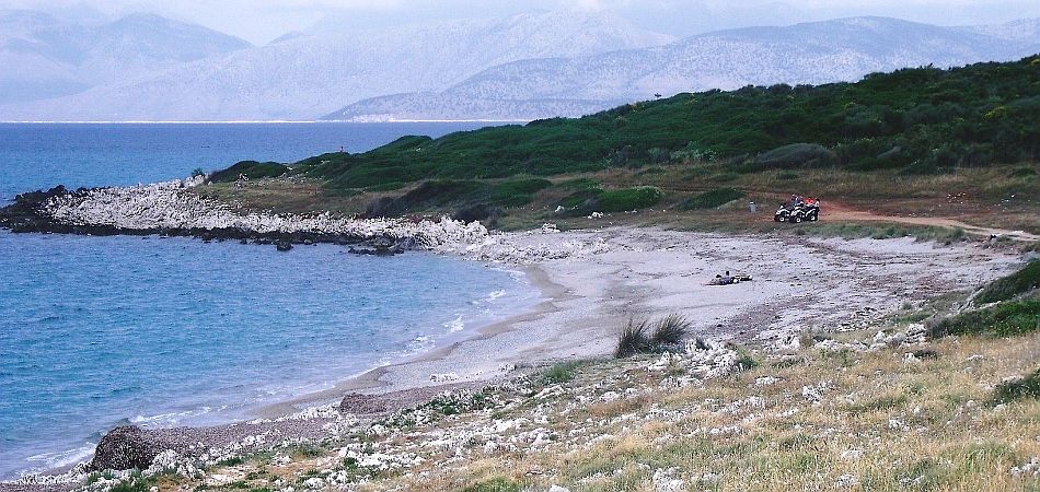
Walking in North East Corfu
Rising to nearly 3000 feet (911 metres) straight from the sea, the Pantokrator Massif dominates Corfu's skyline. Viewed from the south, the 'twin peaks' ('korifoi' in Greek) of Mount Pantokrator and Mihalakades to its south west (852 metres), gave Corfu its westernized name. The south face of the Massif is a sheer wall of rock, with a few breaks where paths climb like staircases. To the north east, the land tumbles to the sea in a riot of gullies, many of them the route of footpaths which link the coast with the mountain settlements. With a coastal footpath (unfortunately not continuous) and high tracks circuiting the Massif, North East Corfu offers number of circular walks on the hillsides which combine sea and mountains. Above, on the rolling limestone heights and plateaux, the landscape is a wilderness where the walker encounters no-one but the odd shepherd.
North East Corfu Walking Region
The North East Corfu walking region extends over the eastern part of the Pantokrator Massif, including its summit, and as far as the sea to the north, east and south. Its westerly border is an imaginary line drawn from Lake Antinioti in the north to Ipsos in the south, and it incorporates the North East Coast, that string of picturesque bays between Nissaki and Kassiopi which are known as 'Kensington-on-Sea'. The resorts of Barbati, Nissaki, Kaminaki, Kalami, Agios Stefanos, Avlaki, Kassiopi and Apraos fall within the region, and its also includes the mountain villages of Loutses, Lafki, Old Perithia and Porta.
North East Corfu Terrain
The rugged terrain of the Pantokrator Massif makes for the roughest walking in Corfu. Depending on a slope's orientation, the olive-tree line reaches to about 400 metres; above this height the mountains are barren, dotted in places with oaks and other hardy trees, and in sheltered valleys forested with high-growing maquis shrubs. The rock is mostly hard limestone, sometimes karstic, and knife-edge sharp in places. During the last couple of decades, some of the graded and cobbled muletracks (kalderimi) which were the main routes through the region have been bulldozed to create mountain tracks, less atmospheric than the old ways but easier on the feet. Particularly just above the coast where the terrain is steep, more of these old paths remain in North East Corfu than in any other part of the island.
Links to other Corfu Walks areas
The Corfu Trail enters the North East Corfu walking region at Spartillas, thereby linking it with regions in Corfu's North West and all regions to the south. It adjoins the Acharavi Hinterland region on its north west boundary. (NOTE: Walks on the eastern section of the Pantokrator Massif are also included in the Walks in North Corfu guide.)
Updating Walking in North East Corfu
As a buyer of the book, your name and email address will be kept on
record, and you will be sent FREE UPDATES upon request.
Maps
Unfortunately, graphics greatly increase the size of a pdf file in this format, and their inclusion would prevent dispatch by email of the document. As a result, this book does not contain maps. The best map of Corfu is Freytag and Berndt's 1:50,000 edition, though it is not 100% accurate, and it does not depict most footpaths.
Plant Lists
Flora Ionica -
An inventory of ferns and flowering plants of the Ionian Islands.
Corfu Flowers - Photographs showing many of the island's flowers, identified and named by a botanist whilst walking the Corfu Trail.
Accommodation
Damianos Apartments,
San Stefano (Agios Stephanos, North East Coast)
Situated only 150 metres from the sea and a two minute walk from the harbour-front tavernas in the beautiful old fishing village of San Stefano, Damianos Apartments are the ideal base from which to explore the many walks and trails of North East Corfu.